One email can change– a lot of things!
Early November 2022, my wife and I were on our way to Houston when I received the email asking about my availability for an interview for Summer 2023 Internship in the Raster Analysis team at Esri. I had to restrain myself from taking an exit and reply immediately. I was nervous, and more importantly, I was excited. Why wouldn’t I? After all these years, I got a call from Esri. The institute I heard about in 2011 when I was a freshman back in Bangladesh– ArcGIS Pro did not exist, and GIS was synonymous with ArcMap. An hour later, I responded to the email, and before we finished our lunch, I had an interview scheduled in two days. The interview went well; however, I was skeptical. To my surprise, I received the offer the following business day, and within the next week, I was officially a summer intern at Esri. At last, I made it to Esri.
It’s an (incredible) experience!
In my first meeting with my mentor, we discussed that my time as an intern would be divided into three parts– develop and complete a capstone project, learn about the day-to-day activities (not literally, I assume at this point!) of product engineers; and learn about product and tool development. Now that I am close to completing my 12-week tenure here, I can confidently say it was nothing short of eventful.
Capstone project
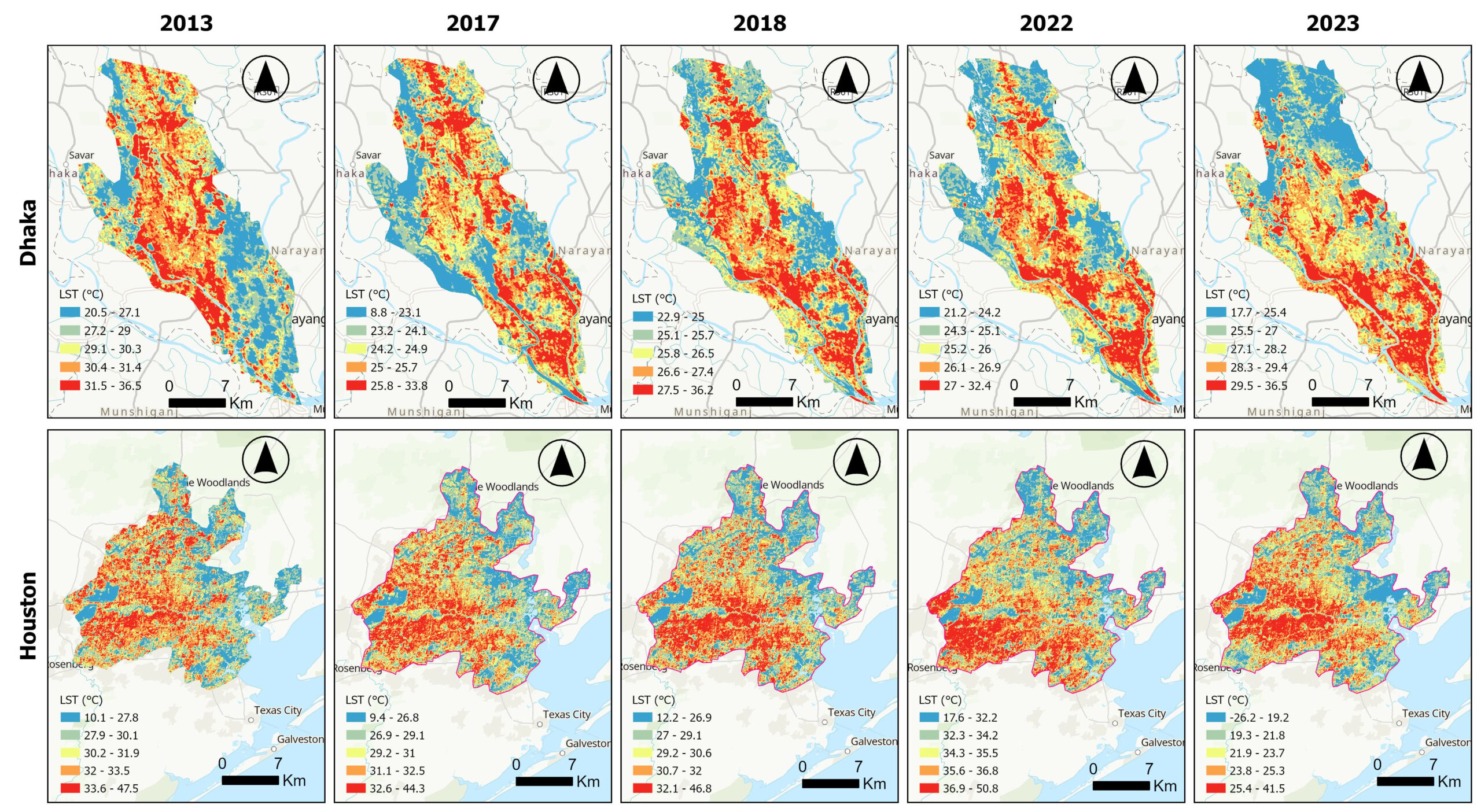
For my internship project, I worked on examining the spatial and temporal variations in urban heat island effects of two rapidly growing cities from the global north and global south. I selected Houston and Dhaka from the respective regions due to these cities’ rapid growth rate (land and population) and economic importance. One of the objectives of this project was to create a reproducible workflow only using ArcGIS Pro’s capacity. Using the Landsat-8 images from USGS, this project examined the spatial and temporal patterns and changes in land surface temperature and urban heat island effects in both these cities between 2013 and 2023. Additionally, as part of the project, different spectral indices for vegetation health (Normalized Difference Vegetation Index (NDVI)), water and aqueous areas (Normalized Difference Water Index (NDWI)), built-up areas (Normalized Difference Built-up Index (NDBI)), and barren lands (Normalized Difference Barrenness Index (NDBal)) were also calculated to understand the changes better. Urban thermal comfort and heat hotspots were also calculated to examine the spatial patterns of heat island effects across time in both cities.

I decided to work on this project as part of my capstone project for a couple of reasons. First, my doctoral dissertation focuses on urban expansion, infrastructure development, the impacts of this growth, and implications on global sustainability. Second, Climate change, global warming, and rapid urbanization are causing extremely hot and long summer seasons globally in recent recorded history. June 2023 was the warmest month on record since 1881 (July appeared to be on the way to break that record), and the record for the warmest temperature in a single day was broken multiple times in the same month. We also witnessed an American city (Phoenix) to average of over 100°F for an entire month (average temperature in Phoenix in July was 102.7°F) (Livingston, 2023). To further exacerbate the already concerning conditions, studies forecasted an increase in air temperature during summer by 0.5°C–0.7°C by 2050, even up to ~3°C in certain places around the world (Huang et al., 2019). Even though the project was almost completed by July, these ongoing heatwaves and extremely dangerous heat index values further justified the rationale of my pursuing the project in the first place.
Getting to know the “behind-the-scenes” of GIS
While working on my internship project was exciting and closely related to my research interest, I was excited about knowing more about how the tools we use every day are created- from conceptualization to getting it to the end-user (at that point, I was the end-user). I was fortunate enough to work on creating the design of a new geoprocessing tool- Space–Time Kernel Density, creating the help and reference documents and addressing the issues in the process. For someone who spent his entire adult life in academic institutions, it was a brand-new experience, which to my surprise, I was enjoying. I got to know how parameters get their names, the thought process of the product engineers and developers, and how a tool is tested. In addition to the tool development and documentation part, I also tested and certified raster analysis tools and raster functions in ArcGIS Online and ArcGIS Enterprise. The word “testing” got a whole new meaning here.
It’s not all about software development– there’s more.
At this point, one may assume it is all about work, and there’s nothing beyond that. I hate to break it; nothing could be further from the truth. The university teams at Esri (they coordinate internship activities) worked relentlessly to organize weekly activities for the interns to get together and do fun activities, know each other, know more about the organization, learn about the cutting-edge works different divisions work on, and the hackathon. Despite being a remote intern, I did not feel I had missed anything for once, thanks to the efforts of the university teams. Getting a front-row seat to the greatest show on the “geospatial world” is fascinating.
Not the end but a new beginning
Like all good things in life, my time as an intern at Esri is also nearing an end. Now that I look back and reflect on my time here, I can confidently say it has been extremely enriching for me- both personally and professionally. I have learned a lot- not necessarily only about spatial analysis or raster analysis tools, but about software development processes, the importance of clear thinking and articulating that, devising use cases for every possible scenario, and continuously working to improve what may seem already perfect. I got to know software development processes, attended Esri User Conference for the first time, met some super cool-super talented folks, and have a new perspective regarding geospatial analysis and making a tangible impact on society. I am glad I decided to come to Esri for the internship, and I look forward to using my experience to solve real-world problems for the greater good.
References
Huang, K., Li, X., Liu, X., & Seto, K. C. (2019). Projecting global urban land expansion and heat island intensification through 2050. Environmental Research Letters, 14(11), 114037.
Livingston, I. (2023, July 21). Phoenix will be the first major U.S. city to average 100-plus degrees all month. Washington Post. https://www.washingtonpost.com/weather/2023/07/21/phoenix-average-monthly-temperature-100-degrees/


Commenting is not enabled for this article.