Yay! We are halfway through this series! Hopefully, you’ve seen by now the Sentinel-1 and ICEYE articles on Demystifying SAR Satellite Data in ArcGIS Pro if not check out the related content below! If you are curious about Synthetic Aperture Radar (SAR) satellite imaging and want to explore the technical capabilities of RADARSAT Constellation Mission (RCM) satellite technology, then you have come to the right place! We’ll discover how the ArcGIS Pro Synthetic Aperture Radar Toolset supports the use of SAR data obtained from the RCM satellites! We’ll dive into questions such as “Who provides RCM data?”, “What SAR products are supported in ArcGIS Pro?”, and “How does the ArcGIS Pro Synthetic Aperture Radar toolset support RCM SAR satellite data?”.
Who provides RCM data?
The Canadian Space Agency (CSA) is responsible for launching and providing the RCM. The CSA focuses on various aspects of space exploration, research, and technology development. The CSA works on satellite missions, space science research, Earth observation, communication technologies, and international collaborations. The RCM plays a crucial role in Canada’s space program and contributes to our understanding of Earth’s environment. This data is made available to the public through the EODMS (Earth Observation Data Management System).
What SAR products are supported in ArcGIS Pro?
Many SAR sensors are available and supported as raster types in ArcGIS Pro and each has various products and polarizations.
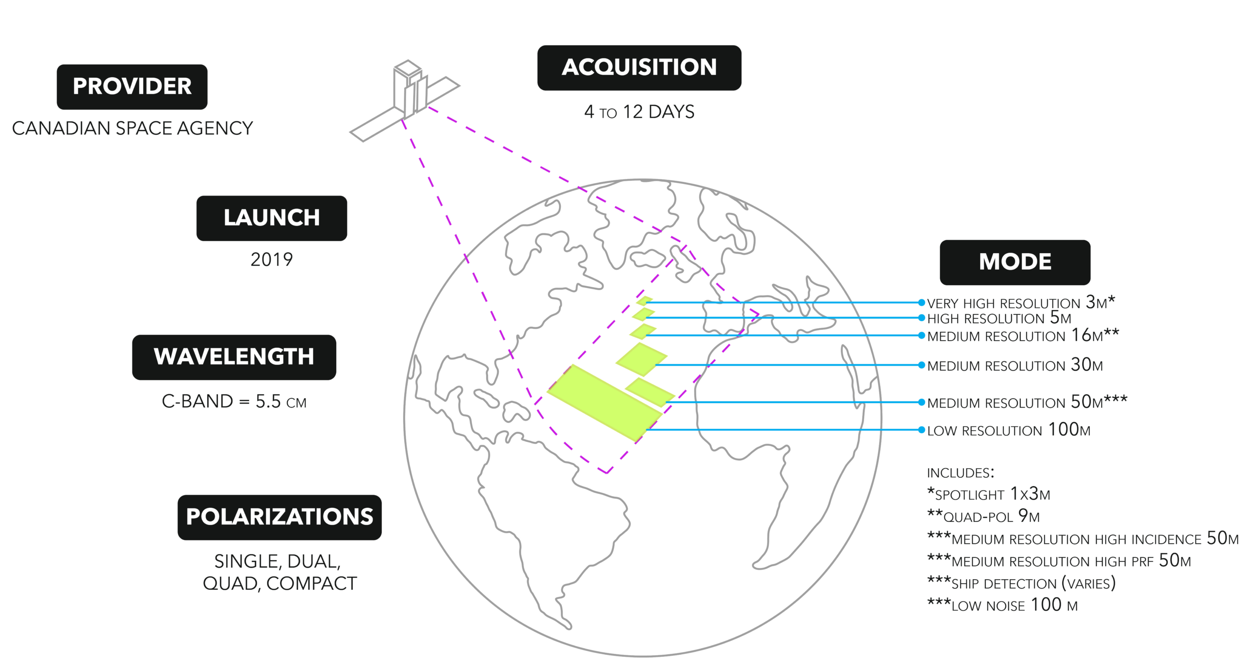
To learn more about the RCM constellation, visit the Canadian Space Agency website.
How does the ArcGIS Pro Synthetic Aperture Radar toolset support RCM data?
Users can access the ArcGIS Pro Synthetic Aperture Radar toolset with the Image Analyst license. ArcGIS Pro treats the supported SAR sensor data as a raster layer with radar properties and capabilities; the support level depends on the sensor. It’s good to note that once the dataset has been processed by a tool outside the Synthetic Aperture Radar toolset, it is no longer considered a radar layer.
The table below lists the geoprocessing tools available for RCM data.
| Remove Thermal Noise | Apply Radiometric Calibration | Apply Radiometric Terrain Flattening | Despeckle | Apply Geometric Terrain Correction | Convert SAR Units | Multilook | Create Color Composite | |
| RCM GRD |
✓ |
✓ | ✓ | ✓ | ✓ | ✓ | ✓ |
✓ |
If you haven’t read “Simple steps to add SAR satellite data to your ArcGIS Pro map”, it might be worth a virtual page turn to learn more about SAR sensors, SAR products, SAR raster products, and SAR raster types. Also, visit this StoryMap about SAR satellite data.


Article Discussion: